 Water-ice clouds, polar ice and other geographic features can be seen in this full-disk image of Mars from 2011. NASA's Mars Curiosity Rover touched down on the planet on August 6, 2012. Take a look at stunning photographs of Mars over the years. Check out images from the Mars rover Curiosity.
  This image was captured in 1976 by Viking 2, one of two probes sent to investigate the surface of Mars for the first time. NASA's Viking landers blazed the trail for future missions to Mars.
  The Valles Marineris rift system on Mars is 10 times longer, five times deeper and 20 times wider than the Grand Canyon. This composite image was made from NASA's Mars Odyssey spacecraft, which launched in 2001.
  The Nili Fossae region of Mars is one of the largest exposures of clay minerals discovered by the OMEGA spectrometer on Mars Express Orbiter. This image was taken in 2007 as part of a campaign to examine more than two dozen potential landing sites for NASA's new Mars rover, Curiosity, also known as the NASA Mars Science Laboratory.
  NASA's Mars Phoenix Lander descends to the surface of Mars in May 2008. Fewer than half of the Mars missions have made successful landings.
  Phoenix's robotic arm scoops up a sample on June 10, 2008, the 16th Martian day after landing. The lander's solar panel is seen in the lower left.
  In 2006, NASA's Mars Exploration Rover Spirit captured a 360-degree view known as the McMurdo panorama. The images were taken at the time of year when Mars is farthest from the sun and dust storms are less frequent.
  The European Space Agency's Mars Express captured this view of Valles Marineris in 2004. The area shows mesas and cliffs as well as features that indicate erosion from flowing water.
  This view is a vertical projection that combines more than 500 exposures taken by Phoenix in 2008. The black circle on the spacecraft is where the camera itself is mounted.
  A portion of the west rim of the Endeavour Crater sweeps southward in this view from NASA's Mars Exploration Rover Opportunity in 2011. The crater is 22 kilometers (13.7 miles) across.
  A photo captured by NASA's Mars Global Surveyor in 2000 offers evidence that the planet may have been a land of lakes in its earliest period, with layers of Earth-like sedimentary rock that could harbor the fossils of any ancient Martian life.
  A U.S. flag and a DVD containing a message for future explorers of Mars, science fiction stories and art about the planet, and the names of 250,000 people sit on the deck of Phoenix in 2008.
  A rock outcrop dubbed Longhorn and the sweeping plains of the Gusev Crater are seen in a 2004 image taken by the Mars Exploration Rover Spirit.
  Although it is 45 kilometers (28 miles) wide, countless layers of ice and dust have all but buried the Udzha Crater on Mars. The crater lies near the edge of the northern polar cap. This image was taken by NASA's Mars Odyssey Orbiter in 2010.
  NASA's Opportunity examines rocks inside an alcove called Duck Bay in the western portion of the Victoria Crater in 2007.
  Pictured is a series of troughs and layered mesas in the Gorgonum Chaos region of Mars in 2008. This photo was taken by Mars Orbiter Camera on the Mars Global Surveyor.
  An image captured in 2008 by NASA's Mars Reconnaissance Orbiter shows at least four Martian avalanches, or debris falls, taking place. Material, likely including fine-grained ice and dust and possibly large blocks, detached from a towering cliff and cascaded to the gentler slopes below.
  This 2008 image spans the floor of Ius Chasma's southern trench in the western region of Valles Marineris, the solar system's largest canyon. Ius Chasma is believed to have been shaped by a process called sapping, in which water seeped from the layers of the cliffs and evaporated before it reached the canyon floor.
 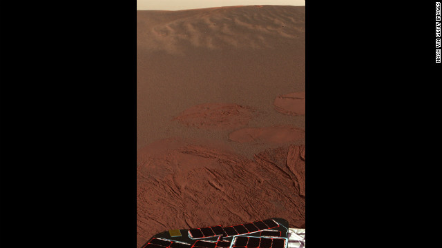 Pictured is the Martian landscape at Meridiani Planum, where the Mars Exploration Rover Opportunity successfully landed in 2004. This is one of the first images beamed back to Earth from the rover shortly after it touched down.
  An image from the Mars Global Surveyor in 2000 shows potential evidence of massive sedimentary deposits in the western Arabia Terra impact crater on the surface of Mars.
 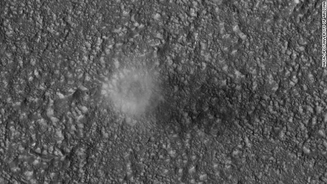 The Mars Reconnaissance Orbiter captures a dust devil blowing across the Martian surface east of the Hellas impact basin in 2007. Dust devils form when the temperature of the atmosphere near the ground is much warmer than that above. The diameter of this dust devil is about 200 meters (650 feet).
  Soft soil is exposed when the wheels of NASA's Mars Exploration Rover Spirit dig into a patch of ground dubbed Troy in 2009.
 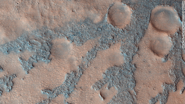 An image from NASA's Mars Reconnaissance Orbiter shows the floor of the Antoniadi Crater in 2009.
  The larger of Mars' two moons, Phobos, is seen in 2008 from the Mars Reconnaissance Orbiter.
  Earth and the moon are seen in 2007 from the Mars Reconnaissance Orbiter. At the time the image was taken, Earth was 142 million kilometers (88 million miles) from Mars.
- Researchers found evidence of seasonal flows
- Orbiter's spectrometer results did not directly find water
- Variations in data from spectrometer suggest seasonal changes
- Further research is needed to find out more
(CNN) -- The presence of water on Mars is often talked about in the past tense -- as in, billions of years in the past. But researchers have found clues that water could be flowing in the present, at least during warm seasons.
Researchers at Georgia Institute of Technology are looking at dark features on Martian slopes that are finger-shaped. They appear and disappear seasonally.
These flows represent the best suggestion we know of that Mars has water right now, scientists say. The study is published in the journal Geophysical Research Letters.
In 2011, Lujendra Ojha and his colleagues announced the evidence for possible saltwater flows on Mars. They published a study in the journal Science based on data from the HiRISE camera aboard NASA's Mars Reconnaissance Orbiter.
Arrows point to dark seasonal flows on Palikir Crater on Mars in this image from NASA's Mars Reconnaissance Orbiter.
As an undergraduate at the University of Arizona, Tucson, Ojha was the lucky one to spot irregular features in a Martian crater he was studying. He had no idea what they were. Researchers spent months figuring it out, and determined that the finger-like shapes could be briny water.
How an undergrad spotted possible water on Mars
"In HiRISE images, we see them forming, elongating and then fading over time," Ojha said Monday. "That's why they're called seasonal -- they form and flow when the temperature is right."
Since that study, Ojha has enrolled in graduate school at Georgia Institute of Technology, and continued studying the phenomena. He and Georgia Tech assistant professor James Wray looked more deeply at 13 sites with confirmed recurring slope features.
This time they found chemical evidence supporting their earlier findings that water flows may appear and disappear on Mars with the seasons.
In most cases, the possible water features appear to last for the equivalent of about two Earth months, Ojha said.
The researchers used the orbiter's Compact Reconnaissance Imaging Spectrometer for Mars (CRISM) instrument to see if they could find more clues of water. CRISM looks for chemical signatures based on the fact that different substances absorb light at distinct wavelengths.
Wavelengths can reveal a lot about what things are made of, Ojha said.
Mystery rock spotted on Mars
An image of seasonal flows is combined with colors representing minerals in the area.
Ojha and colleagues did not find direct evidence of water using the spectrometer method. Instead, they found light absorption features consistent with "something iron in nature" at the flows. The light absorption varied with season, however. The absorption bands are stronger when the features are forming and growing, and weaker when they fade away.
"Something in these areas is actually causing the spectroscopic signature to fluctuate as well," Ojha said.
Water could explain these variations, Ojha said. Water in the seasonal flow would wash away small-sized grains -- dust -- and leave bigger grains. When water is not present, the bigger grains would remain, accounting for the changes in light absorption that researchers observed over time.
Grain sizes could vary without water, though. The Martian atmosphere could also be responsible for some variation in the spectrometer data, because one season is dustier than another, but Ojha thinks there is something else going on.
If there is water on Mars, it would be near to the surface and salty. Specifically, the flows may host an iron-containing mineral called ferric sulfate, a substance known to exist on Mars. Ferric sulfate would bring the melting point of ice down to a lower temperature, Ojha said.
More research needs to be done to confirm this idea, obviously, but if there is briny water on Mars, could we drink it?
No life on Earth could survive in water saturated with ferric sulfate, Wray said in an e-mail.
"But if there's enough water initially to form a dilute solution, maybe it would be OK," he said. "Personally I wouldn't want to risk it!"
Would you?
Water discovered in Martian soil
Follow Elizabeth Landau on Twitter at @lizlandau
No comments:
Post a Comment